Quick Answer:
- Postal Code(s): 00100 & 00603
- Sub-County: Dagoretti North Constituency, Nairobi County
- Location: Western Nairobi, between Lavington and Dagoretti
- Area: Approximately 1.2 km²
- Population (2019 approx.): Around 33,000–38,000 at ward level
- Ward Type: High-density, low-income urban residential ward
- Main Areas: Kawangware shopping centre, Gatina side estates, Stage 2 area, Naivasha Road corridor, Dagoretti Corner environs
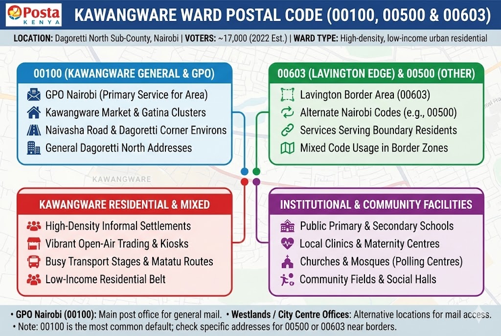
Kawangware uses the general Nairobi code 00100 as its safest primary postal code because many businesses, institutions and directories in the Dagoretti area, including Dagoretti Corner and Naivasha Road addresses, reference 00100 linked to Nairobi GPO rather than a unique local code.
Neighboring Wards & Boundaries
| Direction | Neighboring Ward/Area | Sub-County | Postal Code |
|---|---|---|---|
| North | Lavington area / Kileleshwa side | Largely in Westlands/Kilimani side | 00603 / 00800 (varies by exact estate) |
| South | Dagoretti South side (e.g. Riruta/Dagoretti Corner environs) | Dagoretti South | 00100 / 00512 (varies by specific estate) |
| East | Kilimani/Kileleshwa corridor | Dagoretti North / adjacent constituencies | 00800 (general Westlands/Kilimani code) |
| West | Other Dagoretti neighbourhoods and Gatina side | Dagoretti North / Dagoretti South fringes | 00100 / 00500 (mixed generic Nairobi codes) |
Postal Codes For Kawangware (Dagoretti North)
| # | Ward/Area | Location / Facility | Postal Code | Type |
|---|---|---|---|---|
| MAJOR AREAS & LANDMARKS | ||||
| 1 | Kawangware | General Kawangware residential and market area (western Nairobi) | 00100 | General Area |
| 2 | Kawangware Shopping Centre | General trading centre and bus stage area | 00100 | Commercial |
| 3 | Dagoretti Corner Environs (serving Kawangware) | Umeme Plaza, Dagoretti Corner along Naivasha Road | 00100 | Commercial |
| 4 | Gatina Side (near Kawangware) | Densely built residential clusters near Kawangware-Gatina boundary | 00100 | Residential |
| 5 | Naivasha Road Corridor | Businesses and hostels serving Kawangware residents | 00100 | Mixed Use |
| 6 | Lavington Edge (border area) | Residential edge near Kawangware–Lavington boundary | 00603 | Residential |
| 7 | General Dagoretti North Area | Addresses referencing Dagoretti North with Nairobi GPO | 00100 | Administrative |
| 8 | Kawangware Market Stalls | Informal stalls within main market zone | 00100 | Commercial |
| 9 | Kawangware Informal Settlements | High-density informal housing clusters | 00100 | Residential |
| MAJOR ROADS & ACCESS | ||||
| 10 | Kawangware | Naivasha Road (section serving Kawangware/Dagoretti Corner) | 00100 | Transport |
| 11 | Kawangware | Gitanga Road (link between Kawangware and Lavington) | 00100 | Transport |
| 12 | Kawangware | Kabiria Road (connecting Kawangware to Kabiria/Gatina side) | 00100 | Transport |
| 13 | Kawangware | Ngong Road access via Dagoretti Corner | 00100 | Transport |
| 14 | Kawangware | Internal access roads around Kawangware market area | 00100 | Transport |
| 15 | Lavington Edge (near Kawangware) | James Gichuru Road intersecting Gitanga Road | 00603 | Transport |
| COMMERCIAL & MARKETS | ||||
| 16 | Kawangware Market Area | Open-air produce and general goods market | 00100 | Market |
| 17 | Dagoretti Corner Environs | Umeme Plaza, Dagoretti Corner, Naivasha Road | 00100 | Commercial |
| 18 | Naivasha Road Corridor | Small shops, garages and eateries serving Kawangware residents | 00100 | Commercial |
| 19 | Kawangware Shopping Centre | Retail stalls and supermarkets in shopping centre zone | 00100 | Commercial |
| 20 | Kawangware Stage | Public transport stage businesses (kiosks, MPESA shops) | 00100 | Commercial |
| SCHOOLS & EDUCATION | ||||
| 21 | Kawangware | Selected public primary schools used as IEBC polling centres | 00100 | School |
| 22 | Kawangware | Selected secondary schools serving Kawangware residents | 00100 | School |
| 23 | Gatina/Kawangware Belt | Day primary schools near the Gatina–Kawangware boundary | 00100 | School |
| 24 | Naivasha Road / Dagoretti Corner | Mixed schools accessible from Kawangware | 00100 | School |
| 25 | Lavington Edge (serving Kawangware) | Schools in Lavington that enrol pupils from Kawangware | 00603 | School |
| HEALTHCARE FACILITIES | ||||
| 26 | Kawangware | Local health centres and clinics serving informal settlements | 00100 | Health |
| 27 | Kawangware | Maternity and child health clinics within the ward | 00100 | Health |
| 28 | Dagoretti Corner | Private clinics and medical practices accessible from Kawangware | 00100 | Health |
| 29 | Naivasha Road Strip | Pharmacies and small clinics along Naivasha Road | 00100 | Health |
| 30 | Lavington Edge | Hospitals and clinics in Lavington that serve Kawangware patients | 00603 | Health |
| RELIGIOUS CENTERS | ||||
| 31 | Kawangware | Large churches commonly used as IEBC polling centres | 00100 | Religious |
| 32 | Kawangware | Mosques within high-density residential clusters | 00100 | Religious |
| 33 | Gatina/Kawangware Side | Churches along Kabiria and feeder roads | 00100 | Religious |
| 34 | Dagoretti Corner | Churches that draw congregants from Kawangware | 00100 | Religious |
| 35 | Lavington Edge | Churches in Lavington attended by Kawangware residents | 00603 | Religious |
| RECREATION & NATURE | ||||
| 36 | Kawangware | Local community fields and informal play grounds | 00100 | Recreation |
| 37 | Dagoretti Corner Area | Social halls and small recreation grounds serving Kawangware youth | 00100 | Recreation |
| 38 | Lavington Edge | Green spaces in Lavington used occasionally by Kawangware residents | 00603 | Recreation |
| POSTAL SERVICES | ||||
| 39 | Nairobi GPO | General Post Office Nairobi (serves broader city including Kawangware) | 00100 | Post Office |
| 40 | Westlands / City Centre Offices | Other Nairobi post offices that can handle Kawangware mail | 00100 | Alternative |
Frequently Asked Questions
1. What is the postal code for Kawangware?
00100
2. Where is the nearest post office for Kawangware residents?
Nairobi GPO