Nairobi County, designated as County 047, is Kenya’s capital and largest urban center with a population of over 4.3 million residents according to the 2019 census. The county operates under a devolved government structure established by Kenya’s 2010 Constitution, with its administrative framework divided into 17 sub-counties (constituencies) and 85 electoral wards.
Nairobi County’s governance operates through a hierarchical system:
- County Executive: Led by the Governor and 10 County Executive Committee (CEC) members
- Sub-County Administrators: Manage the 17 sub-counties
- Ward Administrators: Oversee the 85 wards
- Chiefs and Assistant Chiefs: Supervise villages and locations
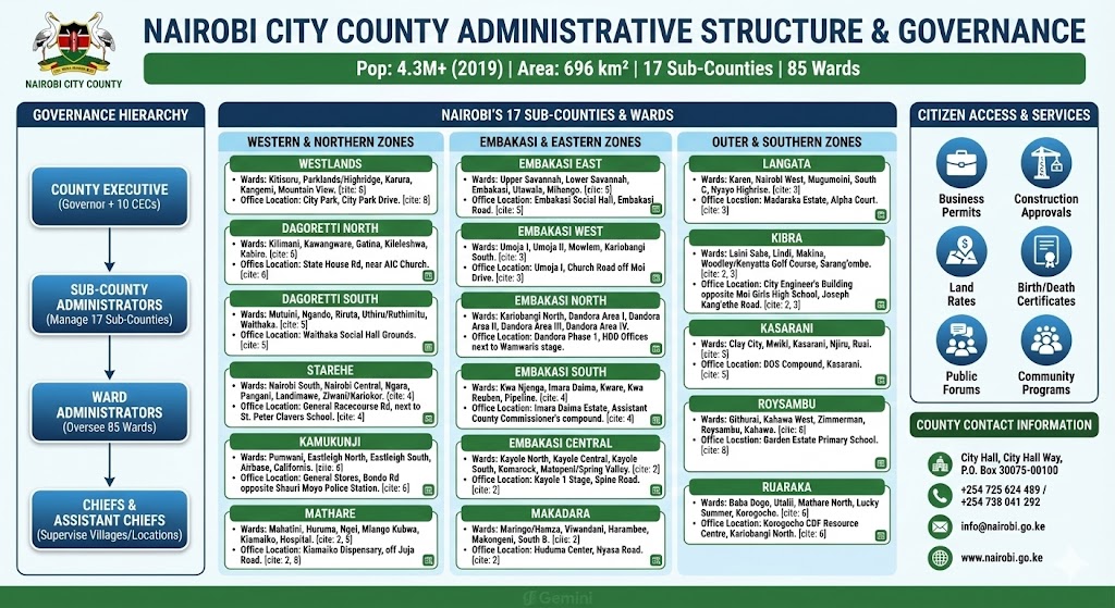
Sub-counties serve as constituencies represented by Members of Parliament (MPs) at the national level. In contrast, wards are represented by Members of the County Assembly (MCAs) who legislate on county matters.
Complete List of Nairobi’s 17 Sub-Counties and Their Wards
1. Westlands Sub-County
Westlands is one of Nairobi’s most affluent sub-counties, covering 72.4 square kilometers. It hosts high-end residential areas like Runda, Kitisuru, and Lakeview, alongside informal settlements such as Kangemi.
Wards in Westlands:
Sub-County Office Location: City Park, City Park Drive
2. Dagoretti North Sub-County
Formed from the larger Dagoretti and Westlands constituencies in 2013, Dagoretti North includes both middle-class and low-income residential areas.
Wards in Dagoretti North:
Sub-County Office Location: State House Road, near AIC Church
3. Dagoretti South Sub-County
Dagoretti South was created when the original Dagoretti constituency was split in 2013.
Wards in Dagoretti South:
Sub-County Office Location: Waithaka Social Hall Grounds
4. Langata Sub-County
As Nairobi’s largest sub-county by area (196.8 square kilometers), Langata includes Karen, one of Nairobi’s most prestigious neighborhoods, as well as Kibera, Africa’s largest urban slum.
Wards in Langata:
Sub-County Office Location: Madaraka Estate, Alpha Court
5. Kibra Sub-County
Covering 12.1 square kilometers, Kibra (formerly Kibera) is home to Kenya’s largest informal settlement and serves a predominantly low-income population.
Wards in Kibra:
Sub-County Office Location: City Engineer’s Building opposite Moi Girls High School, Joseph Kang’ethe Road
6. Roysambu Sub-County
Roysambu was carved from the larger Kasarani constituency in 2013 and serves middle to upper-middle-class residential areas.
Wards in Roysambu:
Sub-County Office Location: Garden Estate Primary School
7. Kasarani Sub-County
Covering 152.6 square kilometers, Kasarani is one of Nairobi’s largest sub-counties by area, extending to peri-urban zones.
Wards in Kasarani:
- Clay City Ward
- Mwiki Ward
- Kasarani Ward
- Njiru Ward
- Ruai Ward (the largest ward geographically at 98 square kilometers)
Sub-County Office Location: DOS Compound, Kasarani
8. Ruaraka Sub-County
Formed in 2013 from Kasarani constituency, Ruaraka has a population of approximately 192,620 residents.
Wards in Ruaraka:
Sub-County Office Location: Korogocho CDF Resource Centre, Kariobangi North
9. Embakasi South Sub-County
Formerly known as Nairobi East constituency, Embakasi South covers 12 square kilometers and includes industrial areas.
Wards in Embakasi South:
Sub-County Office Location: Imara Daima Estate, Assistant County Commissioner’s compound
10. Embakasi North Sub-County
With a population of 181,388, Embakasi North covers 20.8 square kilometers and includes the densely populated Dandora estates.
Wards in Embakasi North:
- Kariobangi North Ward
- Dandora Area I Ward
- Dandora Area II Ward
- Dandora Area III Ward
- Dandora Area IV Ward
Sub-County Office Location: Dandora Phase 1, HDD Offices next to Wamwaris stage
11. Embakasi Central Sub-County
Covering 14.3 square kilometers with a population of approximately 185,948, Embakasi Central serves the Kayole area.
Wards in Embakasi Central:
Sub-County Office Location: Kayole 1 Stage, Spine Road
12. Embakasi East Sub-County
Home to Jomo Kenyatta International Airport, Embakasi East is strategically important to Kenya’s aviation sector.
Wards in Embakasi East:
Sub-County Office Location: Embakasi Social Hall, Embakasi Road
13. Embakasi West Sub-County
Covering 9.35 square kilometers, Embakasi West was established in 2013 and serves the Umoja and Kariobangi areas.
Wards in Embakasi West:
Sub-County Office Location: Umoja I, Church Road off Moi Drive
14. Makadara Sub-County
Covering 13 square kilometers, Makadara was previously known as Donholm and later Bahati constituency.
Wards in Makadara:
- Maringo/Hamza Ward
- Viwandani Ward
- Harambee Ward
- Makongeni Ward
- South B Ward
Sub-County Office Location: Huduma Center, Nyasa Road
15. Kamukunji Sub-County
Formerly the Nairobi Central constituency, Kamukunji covers 12 square kilometers and includes the predominantly Somali neighborhoods of Eastleigh.
Wards in Kamukunji:
Sub-County Office Location: General Stores, Bondo Road opposite Shauri Moyo Police Station
16. Starehe Sub-County
Covering central to northern Nairobi, Starehe includes the Central Business District (CBD).
Wards in Starehe:
Sub-County Office Location: General Racecourse Road, next to St. Peter Clavers School
17. Mathare Sub-County
As Nairobi’s smallest sub-county at just 3 square kilometers, Mathare was formed in 2013 when Starehe’s boundaries were revised.
Wards in Mathare:
- Mabatini Ward
- Huruma Ward
- Ngei Ward
- Mlango Kubwa Ward
- Kiamaiko Ward
- Hospital Ward
Sub-County Office Location: Kiamaiko Dispensary, off Juja Road
How to Access Sub-County and Ward Services
Residents can access various services at sub-county and ward offices including:
- Business permits and licenses
- Construction approvals
- Land rates payments
- Birth and death certificates
- Public participation forums
- Community development programs
Nairobi County Contact Information
For general inquiries:
- Address: Nairobi City Hall, City Hall Way
- P.O. Box: 30075-00100, Nairobi
- Phone: +254 725 624 489 / +254 738 041 292
- Email: info@nairobi.go.ke
- Website: www.nairobi.go.ke
Thank you for sharing this information. It provides an understanding of Nairobi County Government administrative jurisdictions, as well as necessary contacts. I request that you mention the National Government administrative structure to provide a comprehensive resource.