Nairobi County, officially designated as County 047, is Kenya’s capital and smallest county by land area, covering just 696 square kilometers. Despite its size, it’s the country’s most populous and economically vibrant region, home to over 4.3 million people. The county is divided into 17 sub-counties (constituencies) that form the foundation of its administrative structure.
Whether you’re planning a business venture, looking for property, studying geography, or simply trying to understand Nairobi’s layout, having access to accurate county and sub-county maps is essential. Many people search for Nairobi maps for delivery route planning, understanding postal code regions, identifying ward boundaries, or educational purposes.
The county’s boundaries were formally established through the 2010 Constitution, transforming Nairobi from a province into a county government. Nairobi is bordered by Kiambu County to the north and west, Machakos County to the east, and Kajiado County to the south.
🔍 Search Nairobi Postal Codes
Search our comprehensive database of Nairobi postal codes and areas
Need the official Posta Kenya lookup?
Visit Official Posta Kenya →Opens Kenya Post Office official website
Key Features About Nairobi County:
Here are the key geographical and administrative facts about Nairobi County:
- Total Area: 696.1 km² (making it Kenya’s smallest county by land area)
- Borders: Kiambu County (North and West), Kajiado County (South and Southwest), Machakos County (East and Southeast)
- Elevation: Approximately 1,795 meters (5,889 feet) above sea level
- Administrative Divisions: 17 sub-counties (constituencies) and 85 electoral wards
- Population: Over 4.3 million people according to the 2019 Kenya Population and Housing Census
- County Code: 047
- County Headquarters: Nairobi City Hall, City Square
- Climate: Subtropical highland climate with two rainy seasons
- Major Water Bodies: Nairobi River, Ngong River, and several dams
- Protected Areas: Nairobi National Park (117 km²), Karura Forest, Ngong Road Forest
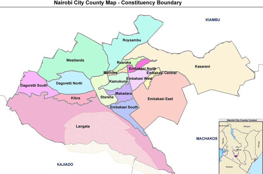
All 17 Nairobi Sub-Counties with Individual Maps
Below you’ll find detailed information about each of Nairobi’s 17 sub-counties, including maps, key facts, major landmarks, and descriptions.
1. Westlands Sub-County Map
Quick Facts:
- Area: 72.4 km²
- Wards: Kitisuru, Parklands/Highridge, Karura, Kangemi, Mountain View
- Major Landmarks: Sarit Centre, Two Rivers Mall, UN Complex, Gigiri, Village Market
- Primary Postal Code: 00800
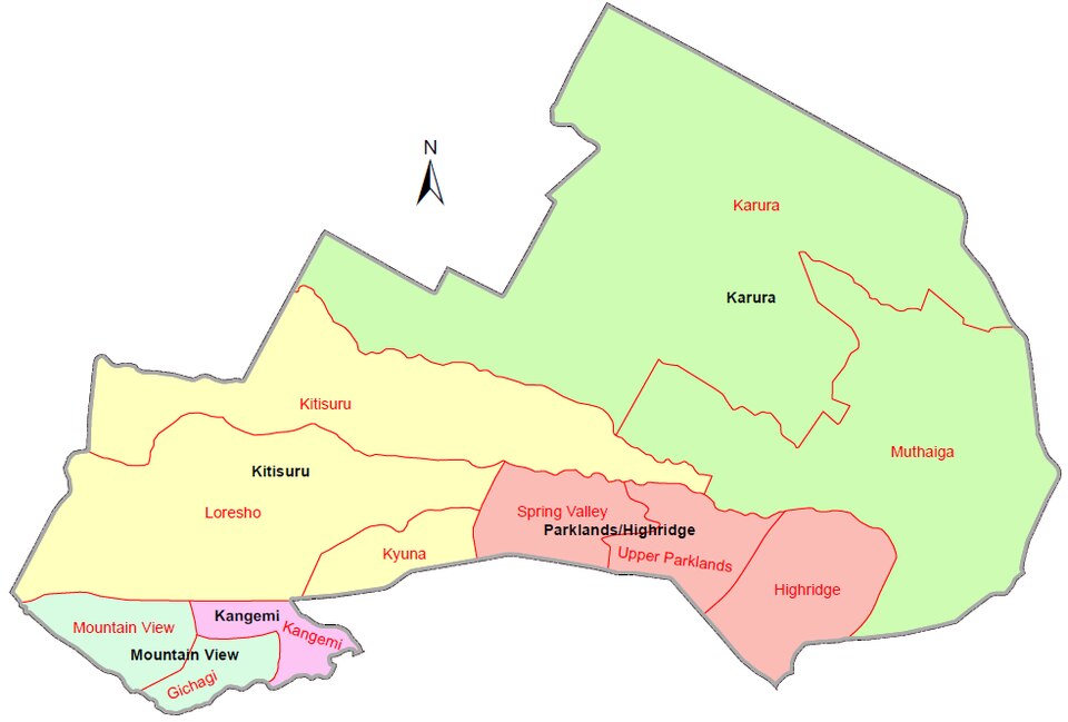
Westlands sits in northwest Nairobi and is one of the county’s most developed sub-counties. It hosts major commercial centers, diplomatic missions, and upscale residential estates like Runda and Kitisuru, alongside informal settlements like Kangemi. The sub-county is a key business and retail hub with numerous shopping malls, hotels, and corporate offices.
2. Dagoretti North Sub-County Map
Quick Facts:
- Area: 32.5 km²
- Wards: Kilimani, Kawangware, Gatina, Kileleshwa, Kabiro
- Major Landmarks: Yaya Centre, Adams Arcade, Nairobi Hospital
- Primary Postal Code: 00603
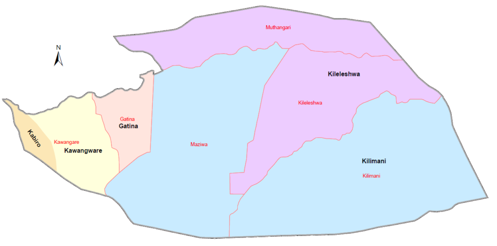
Dagoretti North combines affluent neighborhoods like Kilimani and Kileleshwa with densely populated areas like Kawangware. It’s a mixed-use area featuring residential apartments, shopping centers, hospitals, and vibrant commercial activity along major roads like Ngong Road and Waiyaki Way.
3. Dagoretti South Sub-County Map
Quick Facts:
- Area: 34.1 km²
- Wards: Mutu-ini, Ngando, Riruta, Uthiru/Ruthimitu, Waithaka
- Major Landmarks: Dagoretti Market, Riruta Stadium
- Primary Postal Code: 00507
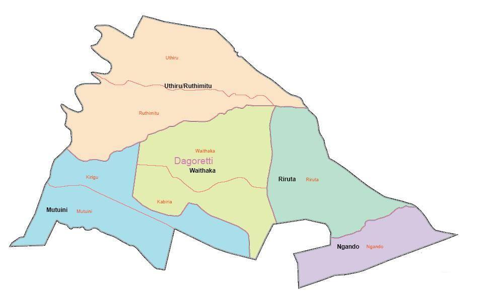
Dagoretti South extends along Nairobi’s western edge and includes both upscale gated communities and middle-income estates. Areas like Riruta and Uthiru have experienced rapid residential development, while Ngando remains a commercial hub serving the surrounding communities.
4. Langata Sub-County Map
Quick Facts:
- Area: 196.8 km²
- Wards: Karen, Nairobi West, Mugumoini, South C, Nyayo Highrise
- Major Landmarks: Nairobi National Park, Giraffe Centre, Bomas of Kenya, Wilson Airport
- Primary Postal Code: 00509
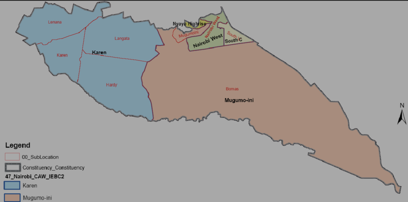
Langata is Nairobi’s largest sub-county by area, home to the famous Nairobi National Park and the affluent Karen suburb. The area offers a stark contrast from luxury estates with large compounds to informal settlements, and houses Wilson Airport, which serves domestic flights and charter services.
5. Kibra Sub-County Map
Quick Facts:
- Area: 12.1 km²
- Wards: Laini Saba, Lindi, Makina, Woodley/Kenyatta Golf Course, Sarang’ombe
- Major Landmarks: Kibera, Olympic Estate, Nairobi Dam
- Primary Postal Code: 00504
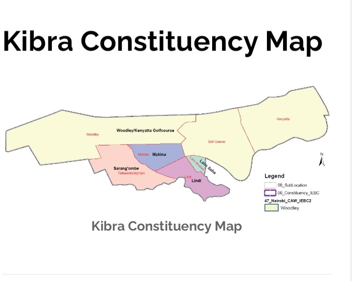
Kibra, previously part of Langata, is one of Nairobi’s most densely populated sub-counties and includes Kibera, one of Africa’s largest informal settlements. Despite challenges, the area is vibrant with strong community organizations, numerous NGO activities, and ongoing urban renewal projects.
6. Roysambu Sub-County Map
Quick Facts:
- Area: 42.3 km²
- Wards: Githurai, Kahawa West, Zimmerman, Roysambu, Kahawa
- Major Landmarks: Thika Road Mall, Garden City Mall
- Primary Postal Code: 00609
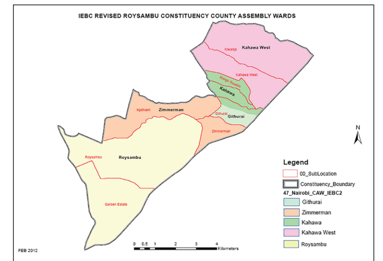
Located in northern Nairobi along Thika Road, Roysambu has transformed dramatically with the construction of the Thika Superhighway. The area features numerous residential apartments, shopping malls, and thriving commercial centers, making it one of Nairobi’s fastest-growing suburbs.
7. Kasarani Sub-County Map
Quick Facts:
- Area: 152.5 km²
- Wards: Clay City, Mwiki, Kasarani, Njiru, Ruai
- Major Landmarks: Kasarani Stadium, Safari Park Hotel, USIU-Africa
- Primary Postal Code: 00608
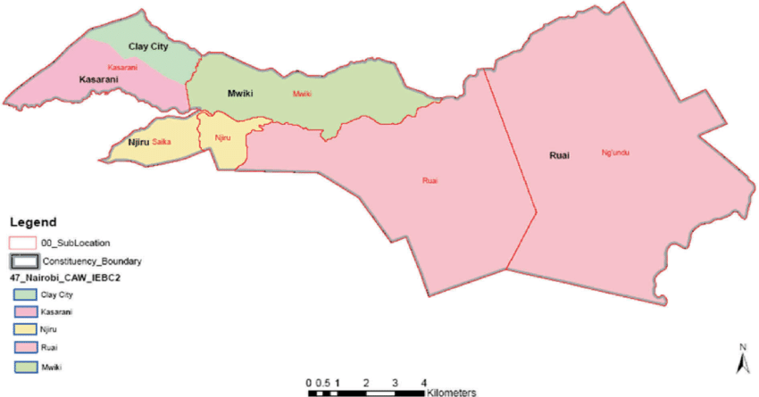
Known for the 60,000-capacity Kasarani Stadium, this sub-county extends to Nairobi’s northeastern edge. It includes the rapidly developing Ruai area and has seen significant residential growth with numerous housing projects catering to middle-income earners.
8. Ruaraka Sub-County Map
Quick Facts:
- Area: 28.4 km²
- Wards: Babadogo, Utalii, Mathare North, Lucky Summer, Korogocho
- Major Landmarks: Kenya Utalii College, Baba Dogo Market
- Primary Postal Code: 00618
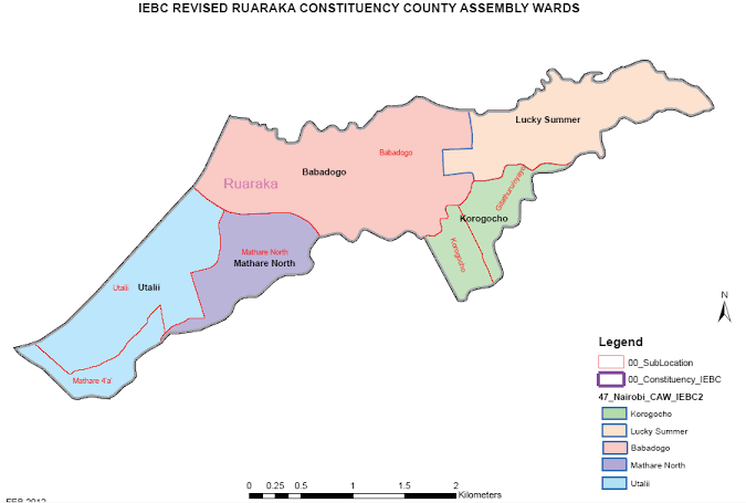
Ruaraka lies between Thika Road and Juja Road and is experiencing significant infrastructure development. The area is home to Kenya Utalii College and features a mix of industrial zones, residential estates, and informal settlements, including Korogocho.
9. Embakasi South Sub-County Map
Quick Facts:
- Area: 38.2 km²
- Wards: Imara Daima, Kwa Njenga, Kwa Reuben, Pipeline, Kware
- Major Landmarks: Jomo Kenyatta International Airport (JKIA), Nyayo Stadium
- Primary Postal Code: 00501
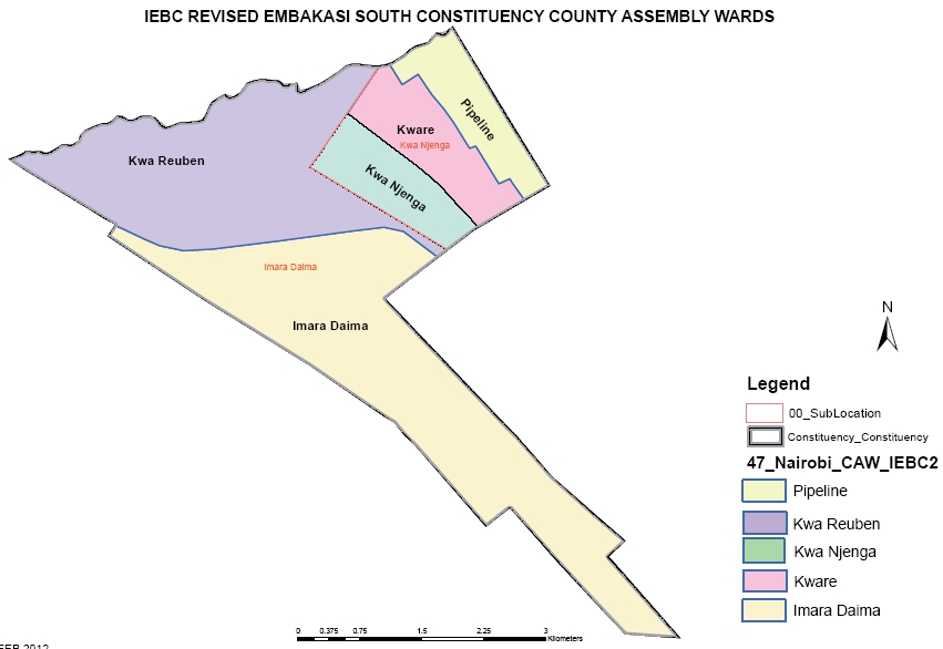
Embakasi South is strategically located near JKIA and serves as a gateway to Nairobi. The area features a mix of industrial parks, residential estates, and informal settlements. Pipeline and Imara Daima are well-known neighborhoods with active commercial centers.
10. Embakasi North Sub-County Map
Quick Facts:
- Area: 29.5 km²
- Wards: Kariobangi North, Dandora Area I, Dandora Area II, Dandora Area III, Dandora Area IV
- Major Landmarks: Dandora Stadium, Ruai Market
- Primary Postal Code: 00516/00615
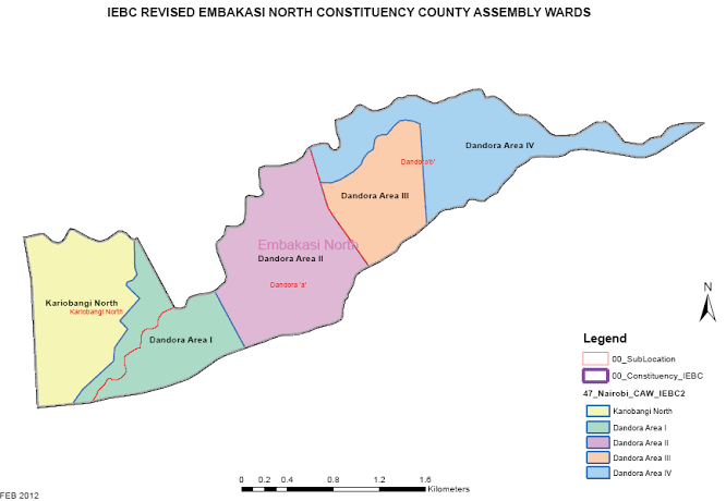
Embakasi North encompasses the Dandora estate and Kariobangi North areas. The sub-county has significant industrial activity alongside residential zones and is home to large manufacturing plants and waste management facilities serving Nairobi.
11. Embakasi Central Sub-County Map
Quick Facts:
- Area: 24.8 km²
- Wards: Kayole Central, Kayole North, Kayole South, Komarock, Matopeni/Spring Valley
- Major Landmarks: Komarock Modern Healthcare, Matopeni Market
- Primary Postal Code: 00518
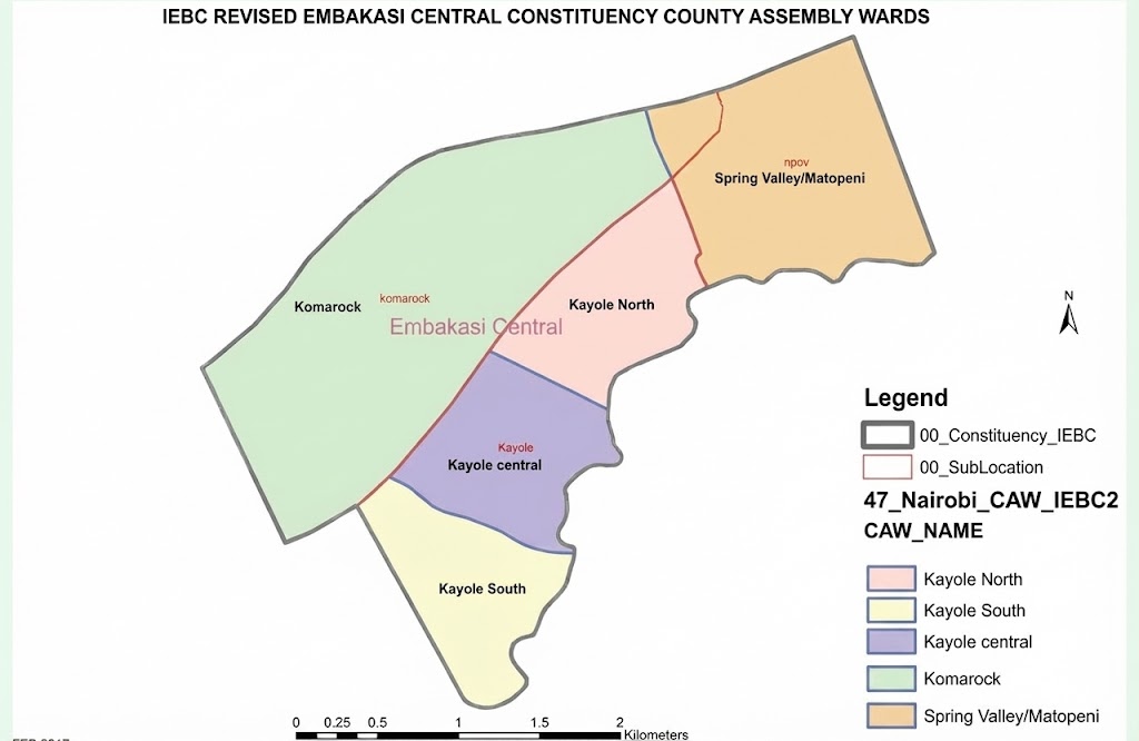
Embakasi Central covers the expansive Kayole and Komarock estates. These are predominantly residential areas with active markets, schools, and churches. The sub-county has experienced steady growth with improved road networks and commercial facilities.
12. Embakasi East Sub-County Map
Quick Facts:
- Area: 36.7 km²
- Wards: Upper Savannah, Lower Savannah, Embakasi, Utawala, Mihango
- Major Landmarks: Donholm Shopping Centre, Buruburu Phase V
- Primary Postal Code: 00521
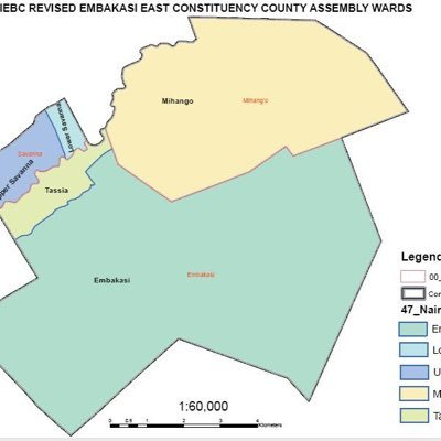
Embakasi East extends to Nairobi’s eastern boundary and includes the rapidly expanding Utawala area. The sub-county features modern residential developments, gated communities, and has become popular among middle-class families seeking affordable housing.
13. Embakasi West Sub-County Map
Quick Facts:
- Area: 18.9 km²
- Wards: Umoja I, Umoja II, Mowlem, Kariobangi South
- Major Landmarks: Buruburu Shopping Centre, Umoja Estate
- Primary Postal Code: 00500
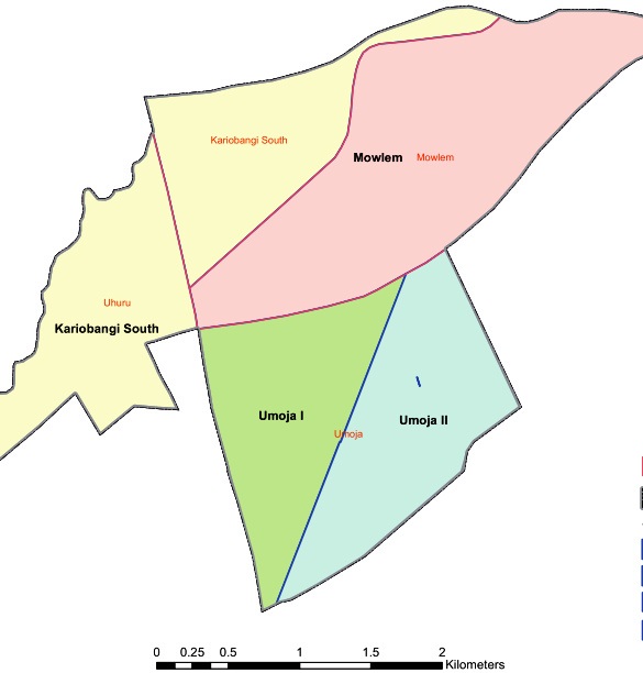
Embakasi West is home to established estates like Umoja, Buruburu, and Kariobangi South. The area is well-developed with mature infrastructure, schools, hospitals, shopping centers, and excellent public transport connectivity to the CBD.
14. Makadara Sub-County Map
Quick Facts:
- Area: 13.4 km²
- Wards: Maringo/Hamza, Viwandani, Harambee, Makongeni
- Major Landmarks: Makadara Law Courts, City Stadium, Industrial Area
- Primary Postal Code: 00522
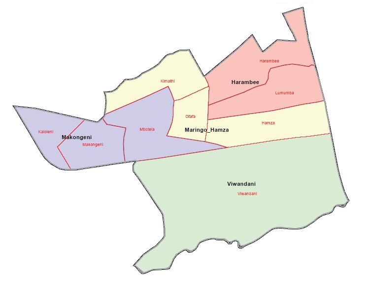
Makadara is one of Nairobi’s older sub-counties, located close to the CBD and Industrial Area. The area has a rich history and includes densely populated estates with strong community ties. It’s well-connected by road and rail networks.
15. Kamukunji Sub-County Map
Quick Facts:
- Area: 13.8 km²
- Wards: Pumwani, Eastleigh North, Eastleigh South, Airbase, California
- Major Landmarks: Eastleigh Business District, Pumwani Maternity Hospital
- Primary Postal Code: 00610
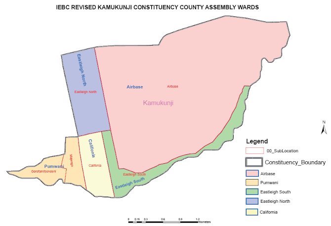
Kamukunji includes the famous Eastleigh neighborhood, known for its vibrant business community and wholesale trade. The area is a major commercial hub for electronics, textiles, and imported goods, attracting traders from across East Africa.
16. Starehe Sub-County Map
Quick Facts:
- Area: 20.6 km²
- Wards: Nairobi Central, Ngara, Pangani, Ziwani/Kariokor, Landimawe,
- Major Landmarks: Kenyatta International Convention Centre (KICC), Parliament Buildings, City Hall
- Primary Postal Code: 00200
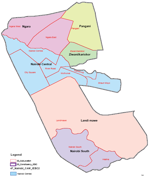
Starehe houses Nairobi’s Central Business District (CBD) and is the political and commercial heart of Kenya. The sub-county includes government offices, corporate headquarters, hotels, and major landmarks that define Nairobi’s skyline.
17. Mathare Sub-County Map
Quick Facts:
- Area: 9.2 km²
- Wards: Hospital, Mabatini, Huruma, Ngei, Mlango Kubwa
- Major Landmarks: Kenyatta National Hospital, Mathare North Hospital
- Primary Postal Code: 00611
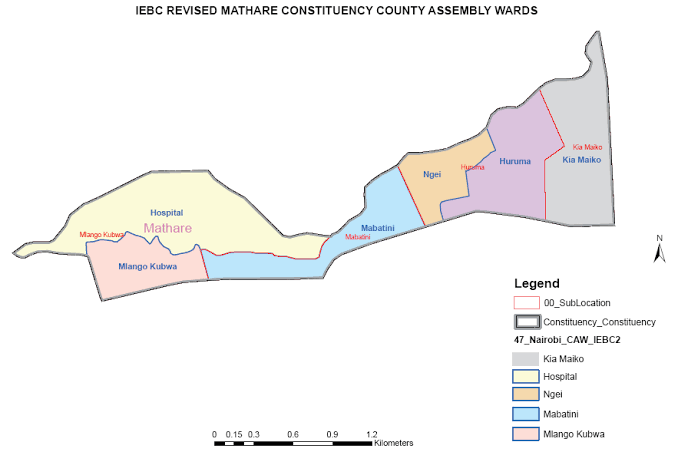
Mathare is a compact sub-county east of the CBD, encompassing both Kenyatta National Hospital (East Africa’s largest referral hospital) and the Mathare informal settlement. The area represents Nairobi’s healthcare hub while facing ongoing urban development challenges.
Nairobi County Neighboring Counties
| County | Cardinal Direction from Nairobi | Key Boundary Areas / Touchpoints |
|---|---|---|
| Kiambu County | North & West | Ruaka, Banana, Kikuyu |
| Machakos County | East & Southeast | Utawala, Ruai, parts of Mombasa Road |
| Kajiado County | South & Southwest | Ongata Rongai, parts of Lang’ata, near Karen edges |
Downloadable & Printable Maps
All maps featured on this page are available for free download and printing. Whether you need them for school projects, business planning, office reference, or personal use, you’re welcome to save and use these maps.
How to Download Maps:
- Right-click on any map image
- Select “Save image as…” from the menu
- Choose your preferred location on your computer
- Save the file
The maps are provided in high-resolution formats suitable for printing on standard A4 or letter-size paper. For best printing results, use quality paper and color printing settings.
Terms of Use:
- Free for personal, educational, and non-commercial use
- You may print and share these maps for legitimate purposes
- Attribution to NairobiPostalCode.org is appreciated but not required
- Do not resell or redistribute for commercial gain
- Do not claim copyright over these maps
Frequently Asked Questions
Nairobi County has 17 sub-counties (also referred to as constituencies). These are: Westlands, Dagoretti North, Dagoretti South, Langata, Kibra, Roysambu, Kasarani, Ruaraka, Embakasi South, Embakasi North, Embakasi Central, Embakasi East, Embakasi West, Makadara, Kamukunji, Starehe, and Mathare. Each sub-county is further divided into electoral wards, totaling 85 wards across the entire county.
Nairobi County is bordered by three counties: Kiambu County to the north and west, Kajiado County to the south and southwest, and Machakos County to the east and southeast.
Langata is the largest sub-county in Nairobi County, covering approximately 196.8 km². This accounts for about 28% of Nairobi’s total land area.
Yes, all maps on this page are completely free to download for personal and educational use. Simply right-click on any map image and select “Save image as…” to download